Design store powered by Zazzle - custom gifts, personalized products, quality printing
Price: $112.00
Style: 60x80 (Choose more styles...)
Manualww fleeceblanket created by VintageSketch (February 2, 2023, 8:02 pm)
Product ID: 256966832215293704
You may also like: (old+america+military+image+restoration)
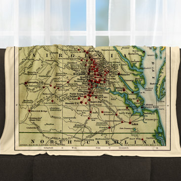
Published in 1912, this map shows the locations of Union vs. Confederate battles in Virginia and surrounding states during the Civil War period of 1861-1865. It also includes the major battles and campaigns, key roads, railroads, rivers, towns, and cities of the time period. It gives a vivid picture of the war and its effects on the Virginia landscape. The map provides an invaluable resource for historians, students, and Civil War enthusiasts alike. Edited by VintageSketch to repair age-related damage and to enhance for print.
Title: Map of Virginia and neighboring states showing the location of battles in the Civil War 1861-1865.
Published: Buffalo, N.Y., The Matthews-Northrup Works
Also shows: Maryland, West Virginia, Pennsylvania, North Carolina
Customize your gifts before you buy them! With Zazzle, create the perfect gift for any occasion and specify what it is that they should send in a message. You can customize anything with the free design tool on their site. Your friends will be so excited when they open up an envelope or a package of goodies just for them after all your hard work designing something special instead of buying off a rack at some big box store where everything looks the same year round!
